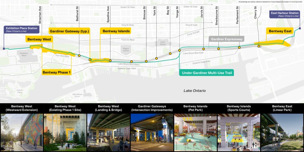
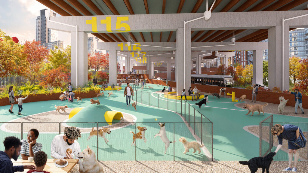
The Bentway is transforming the spaces beneath the Gardiner Expressway into a vibrant network of active, creative destinations.
Building on the vision of the Under Gardiner Public Realm Plan, our growth strategy seizes a once-in-a-generation opportunity to amplify public life along the full length of this vital corridor—leveraging major City and Provincial investment to unlock new possibilities at every turn.
At its core, this plan reimagines the Gardiner as more than transportation infrastructure, transforming the fragmented spaces below the Expressway into a connected civic spine. New Bentway hub sites will anchor communities with essential public amenities and dynamic, year-round programming. A continuous multi-use trail will stitch the city together, strengthening first- and last-mile connections to emerging transit and expanding active transportation across downtown. Along the way, revitalized under-Gardiner intersections will evolve into safer, more welcoming gateways, opening up new pathways to Toronto’s waterfront. This plan redefines how infrastructure can serve the city—turning overlooked spaces into places of connection, and possibility.
Read on to learn more.
Under Gardiner Multi-Use Trail
a continuous 7km connection from Dufferin Street to the Don Valley
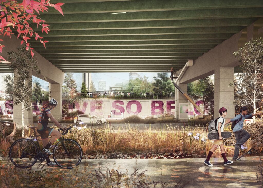
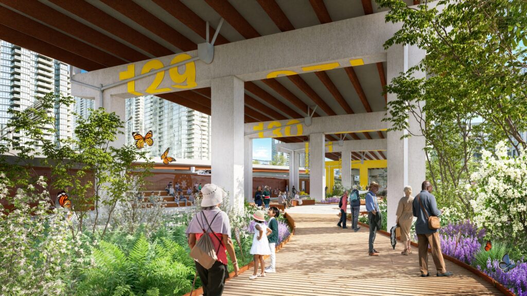
A continuous multi-use trail is a key recommendation from the Under Gardiner Public Realm Plan, and will transform how people move through the city, creating a more welcoming, walkable, and connected urban experience.
The Under Gardiner Multi-Use Trail study sets out a clear path to close critical gaps in Toronto’s active transportation network, introducing intuitive wayfinding and a consistent rhythm of amenities—from seating and lighting to rest areas—that support comfort, safety, and ease of use for everyone.
Spanning 7 kilometres from Dufferin Street to the Don Valley, the completed route will link key civic destinations across the corridor—establishing a seamless east–west link and promoting better connections between the evolving waterfront and the growing city to the north.
What to expect:
- An 7km trail supporting active living and new connections across Toronto’s downtown core
- Design strategies that prioritize safety, accessibility, a strong sense of place, consistent amenities, and year-round use
- Connections to the Trans Canada Trail, Martin Goodman Trail, Dan Leckie bikeway, Canoe Landing Park Trail, Waterfront Trail, and Lower Don River Trail
Design Team: The current Under-Gardiner Multi Use Trail (MUT) study is being led by BA Group in conjunction with Fathom Studio, and 02 Planning + Design, who bring their widely trusted approach and interdisciplinary experience to the project.
Timeline: The Under-Gardiner Multi Use Trail (MUT) study is now underway and will wrap up in Q3 2026 following review by City of Toronto staff. Implementation of the plan will be carried out by multiple stakeholders across the Gardiner Corridor as major infrastructure projects, including the Gardiner Refurbishment and re-alignment, are completed.
Partners:
- City of Toronto Transportation Services Division
- City of Toronto Waterfront Secretariat
Supporters:
- City of Toronto
- Waltons Trust
- RBC Foundation
Gardiner Gateways
intersection improvements linking the city and the waterfront
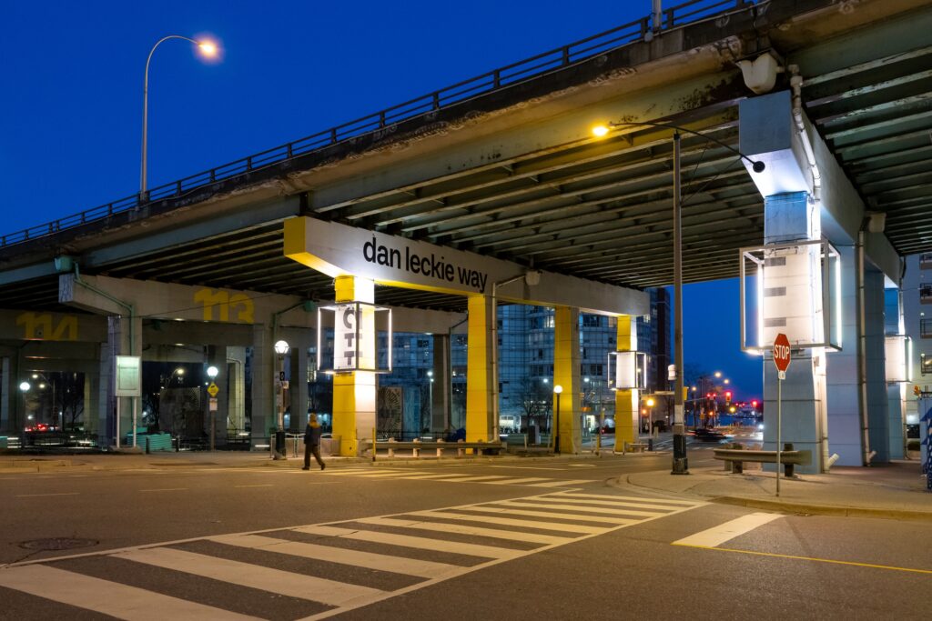
The Gardiner Gateways program reimagines intersections and underpasses across the corridor as vibrant, welcoming thresholds to the waterfront. Through bold use of colour, lighting, and consistent wayfinding, these spaces are transformed from challenging crossings into legible, engaging entry portals—enhancing visibility, elevating the pedestrian experience, and improving safety at some of the city’s most complex conditions.
What to expect:
- Safer, well-lit, and more inviting pedestrian crossings
- Consistent wayfinding to help improve navigation across the waterfront neighbourhoods
- Enhanced access between the downtown core and the waterfront, and improved experiences when travelling to key businesses and attractions, including Scotiabank Arena, Rogers Centre, Harbourfront Centre, Bathurst Quay, Billy Bishop Airport and BMO Field
Design Team: Internationally celebrated designers, Light Bureau, have lead design with Walter Fedy providing structural design and fabrication coordination.
Timeline: Pilot projects are complete at the Dan Leckie Way and Bathurst Street Intersections, with more to come!
Partners:
- City of Toronto BIA Office
- City of Toronto Transportation Services Division
- City of Toronto Waterfront Secretariat
- FIFA World Cup 2026™ Toronto Secretariat
Supporters:
- FIFA World Cup 2026™ Toronto Secretariat
- City of Toronto – BIA Office
- Waterfront BIA
- CityPlace and Fort York BIA
- Concord Adex
- Choice Properties
- Billy Bishop Toronto City Airport
- PowerlinePlus
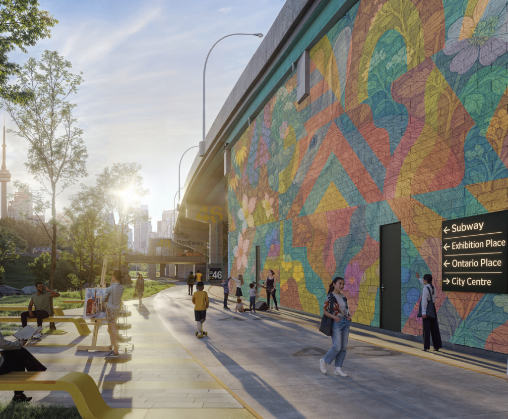
Bentway West
an expanded cultural campus on the western waterfront
Following a long-standing partnership with Exhibition Place, we have announced a transformative westward expansion to The Bentway’s Phase 1 site, marking a critical step in the development of the corridor and growing the public space offerings along the Gardiner. This work is complimented by plans to construct a pedestrian and cycling bridge on the east end of the Phase 1 site, spanning Fort York Blvd, improving access to the Fort York National Historic Site, and linking the existing Bentway site to Bathurst St.
What to expect:
- An expanded cultural platform supporting new experiments in public art and programming, including the Gardiner Wallworks series which displays rotating large-scale murals on the 10,000 sq. ft. concrete wall below the Gardiner facing Liberty Village
- Benway West Loop connection to the Trans Canada Trail
- First-mile/last-mile connection to the improved Exhibition Place Station constructed as part of the Ontario Line
- A landmark bridge to facilitate new vistas of the Fort York National Historic site and neighbourhood connections for over 100,000 residents
- 90,0000 sq. ft. of new public space and accessible connection
Timeline:
- Following the completion of a feasibility study in 2025, schematic design for the Bentway West extension is planned to kick off in Q2 2026.
- Anticipated Design phase: 2026-2027
- Anticipated Construction: 2030-2032
Partners:
- Exhibition Place
- City of Toronto Waterfront Secretariat
- City of Toronto Transportation Services Division
- Fort York National Historic Site
- Metrolinx
Supporters:
- City of Toronto
- Waltons Trust
- Exhibition Place
- Trans Canada Trail
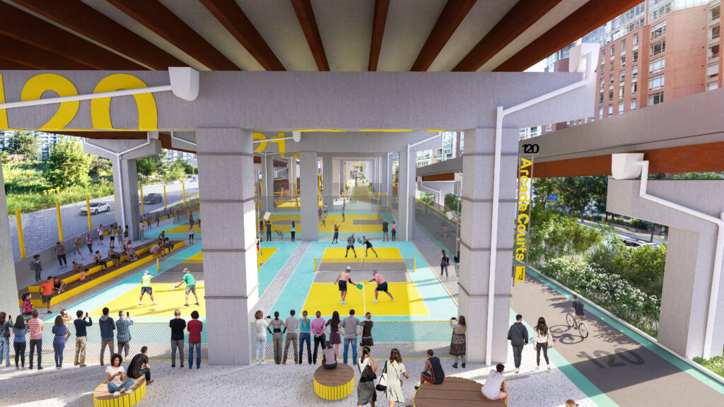
Bentway Islands
a new urban playscape at the foot of Spadina Ave
The Bentway Islands reimagines three large-scale traffic islands spanning 125,000 sq ft. of underutilized space beneath the Gardiner. The design transforms the inaccessible spaces into an extension of Canoe Landing Park and a vibrant, ecological landscape on the central waterfront for gathering, programming and play for all ages.
What to expect:
- Signature all-season facilities for recreation, sport, and play
- A network of regenerative, climate-responsive landscapes
- Space for micro-retail and social entrepreneurship
- Integrated indigenous design elements and gathering places
- 125,000 sq ft of new public space
Design Team: The design for Bentway Islands is led by New York-based Field Operations, a renowned landscape architecture and urban design practice, in collaboration with Toronto-based Brook McIlroy, a planning and architectural practice recognized for its Indigenous design and placemaking projects across Canada.
Timeline:
- Schematic design phase for Bentway Islands was completed in March 2026. This design has received a vote of support from the Waterfront Design Review Panel. Further progress on the project will follow the completion of Gardiner Rehabilitation between Dan Leckie Way and Spadina Avenue.
- Design Phase: 2025-2027
- Construction: 2029-2031
Partners:
- City of Toronto Waterfront Secretariat
- City of Toronto Parks and Recreation Division
- City of Toronto Transportation Services Division
- City of Toronto Urban Design
Supporters:
- City of Toronto
- Waltons Trust
- RBC Foundation
- Balsam Foundation
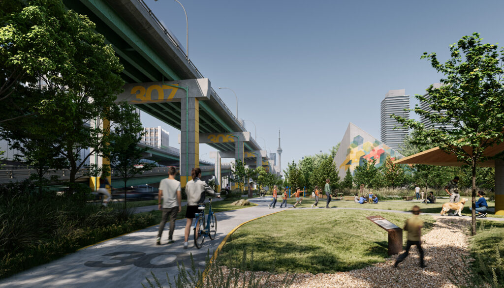
Bentway East
a key waterfront gateway where the Gardiner meets the DVP
Marking a key gateway to Toronto’s eastern communities, Bentway East will serve as a vital trailhead—linking the Trans Canada Trail, the future Loop Trail, and the Under Gardiner Multi-Use Trail into a seamless network. The site also strengthens connections to the future Ontario Line station at East Harbour and improves access to Ookwemin Minising, supporting the growth of Toronto’s newest neighbourhood.
At the confluence of the Don River and the Gardiner Expressway, Bentway East will host cultural and recreational programming that reflects the energy of this meeting point—enhancing connectivity and establishing a dynamic new gateway to the waterfront.
What to expect:
- A welcoming trail-head connecting north-south-east-west at the mouth of Don River
- First-mile/last-mile trail connectivity to East Harbour station
- Focus on urban ecology, education, and active transportation
- Improved gateways to the Port Lands, the Don River, and Lake Ontario
- 105,000 sq ft of connective space
Timeline: Details forthcoming
Partners:
- City of Toronto Waterfront Secretariat
- City of Toronto Parks and Recreation Division
- City of Toronto Transportation Services Division
- City of Toronto Urban Design
- Toronto and Region Conservation Authority (TRCA)
- Metrolinx
Supporters:
- Evergreen
- Waltons Trust